Habitation Fond Rousseau

Habitation Fond Rousseau is a little-known historical site in the commune of Schœlcher. Formerly known as Fond Plumet, it owes its name to Charles Rousseau, one of whose distillation column was brought to the Habitation after the eruption of Montagne Pelée in 1902. The Habitation was built in the 17th century to produce sugar, indigo, coffee, cocoa, petun and later rum. First owned by Judge Gabriel Turpin and his sister Marie in 1671, it was bought by the Hurault de Manoncourt family more than 10 years later, who devoted themselves to growing mulberry trees for silkworm breeding.

Habitation Fond Rousseau comprises a 176 m² main house, a kitchen and a 42 m² outbuilding, a pavilion, a former rum-making factory, a garage, two large carbets, a tropical garden, a coconut grove, a former sheepfold and several parking spaces.

It has private access to the Case Navire river.

Amerindian remains have been found here.

Today, Habitation Fond Rousseau is privately owned. There is a partnership with the town of Schœlcher to organize tourist visits.

Plantation Leyritz

Within a verdant tropical park and surrounded by century-old trees, Plantation Leyritz is an old habitation located in the North Atlantic which has preserved the remains of its period buildings. It was an old agricultural domain, certainly the most important of the West Indies if we take into account the number of its buildings. It was founded by a noble from Bordeaux, Michel de Leyritz (1681-1764) who had settled in the North Atlantic region of the island for several years.

From then on, a system of planting crops was set up according to the needs and trends of the time (spices, cassava, tobacco, citrus fruits and of course sugar cane). Nowadays, there are still plantations of bananas and pineapples.

After its creation, as was the case in the rest of the island's settlements, Michel de Leyritz called upon slaves from Africa to work in the plantations. In 1771, there were 336 slaves working on the fields of the site which covered an area of 497 hectares. Then the number of slaves present on the site will decrease following the end of the slave trade.

After the abolition of slavery, paid black workers and "koulis" were in charge of field work and the production of sugar cane products (rum, sugar and tafia).

In 1970, it was transformed into a hotel-restaurant while preserving the historical buildings (sugar mill, distillery, water mill and the case-nègres street) as best as possible.

Leyritz Plantation is also known for having been the host of a Franco-American summit between the President of the Republic at the time, Valery Giscard d'Estaing and Gerald Fort, the President of the United States, from December 14 to 16, 1974.

In 1979, it was hit hard by Hurricane David before being restored and welcoming visitors from around the world.

In 2007, the Leyritz Plantation was partially destroyed by Hurricane Dean and did not reopen its doors to visitors. In addition, due to funding difficulties, the site has not been renovated.

Moulin de Val d'Or

The Moulin du Val d'Or (Val d'Or mill) is one of the many witnesses to Martinique's slave-owning past. It was erected in the 18th century on the Habitation du Val d'Or to facilitate the crushing of sugar cane. With a height of 18 meters, it was the central element of the old plantation and the point of connection between the plantation, i.e. the place of the sugar production, and the pier of the seaside from where the goods were transported.

Concerning its operation, the mill was operated by mules and was a symbol of the mechanical technology of the time to produce sugar cane. Later, it was completely restored in order to repair the walls, the roof and the carousel mechanism. It continued to be used even after the installation of the steam engine in 1882. The construction of the Marin factory will cause its usage to decrease until it is no longer used.

The Val d'Or mill is to this day, the only animal mill still in use in the Caribbean. It is one of the sites of the Parc Naturel Régional de la Martinique (Regional Natural Park of Martinique). It is classified today as a Historical Monument.

During the guided tours, you will be able to discover the remains of the sugar factory nearby and attend an animation where donkey-makers and guides will make you discover the techniques of the time of crushing of the cane.

Fort Desaix

Fort Desaix overlooking the city of Fort-de-France was erected between 1765 and 1774 on the Morne Garnier at 146 meters above sea level.

At the time, there were many colonial wars, the European powers waged merciless wars to conquer the greatest number of territories in the Caribbean. It must be said that the islands produced coffee, cocoa, sugar or rum which sold for exorbitant prices once they arrived on European markets.

The English and the Dutch are the main opponents of the French who had conquered and colonized Martinique since 1635.

Following yet another attack by the English in 1762, King Louis XV decided to improve the island's defense system by providing it with a new fort high up on the Morne Garnier. This fort by its positioning would be able to more quickly see the enemies lurking in the area.

First named Fort Bourbon, it was then renamed Fort de la Convention before finally being called Fort Desaix.

6 million pounds were sent to begin work in 1764 under the direction of Lieutenant-Colonel de Rochemore. The fortification technique would be the same as that developed a century earlier by Vauban, an engineer and French military architect. The work was completed in 1772 and the fort was then named Fort Bourbon in homage to King Louis XV who had decided to build it.

Fort Bourbon will play a decisive role during the war of independence of the United States because the English will never succeed in attacking the city of Fort-Royal (former name of Fort-de-France) which was the base of the French regiments engaged to American insurgents.

In 1793, the fort was renamed Fort la Convention and was an impregnable fortress during the Capture of Martinique by the English in 1794. The 900 men locked up by General de Rochambeau resisted the 16,000 English who invaded Martinique.

Following the French capitulation, the fort was renamed Fort George by the English who remained in control from 1794 to 1802. After the Treaty of Amiens of March 25, 1802, Martinique was returned to the French by the English and Napoleon 1st then Emperor of the French, gives it its definitive name, Fort Desaix in homage to one of his generals, Louis Charles Antoine Desaix killed during a battle.

No longer suitable for combat towards the end of the 19th century, the fort was restructured several times to serve as support for coastal artillery batteries.

During the Second World War, under the administration of Admiral Robert, the fort housed 286 tons of gold from the Bank of France that was destined for Canada.

In 1961, Fort Desaix became a barracks housing the 33rd Marine Infantry Regiment and the General's headquarters.

In 2009, the fort will be listed as a historical monument before being removed in 2011 following work.

Today the building includes no less than 34 buildings within the walls as well as several bastions and three exterior half-moons, the largest of which measures 90 meters at the base. Fort Desaix remains the headquarters of the Superior Command of the Armed Forces in the French West Indies and Guyana.

Photo gallery
Fort Desaix
Fort Desaix

Maison d'Aimé Césaire

The maison d'Aimé Césaire (Aimé Césaire's house) is the place where you can learn the most about the poet during your stay on the island. Acquired in the 1960s to live there with his family, it still contains many objects that belonged to the writer as well as memories that he had treasured during his lifetime.

Today, the place is a space for exchanges, meetings and cultural events linked to the memory of Aimé Césaire.

The poet after becoming Mayor of Fort de France from 1946 until 2001.

Aimé Césaire died on April 17, 2008, at the age of 94.

Located in a residential area at 131 route de Redoute in Fort de France, the site is classified as a historic monument. This label concerns the dwelling house, the outbuildings, the garden, the enclosure walls and the ground of the plot.

The house of Aimé Césaire is today an integral part of the Martinican heritage.

Photo gallery
Maison d'Aimé Césaire
Maison d'Aimé Césaire panneau à l'entrée
Maison d'Aimé Césaire

Habitation Beauséjour

Habitation Beauséjour is located at the northern tip of Martinique, in the commune of Grand-Rivière. Built in the 18th century, the estate witnessed the evolution of various crops during the period of slavery. Cacao, sugarcane, banana, and later sugarcane again were cultivated successively on its lands.

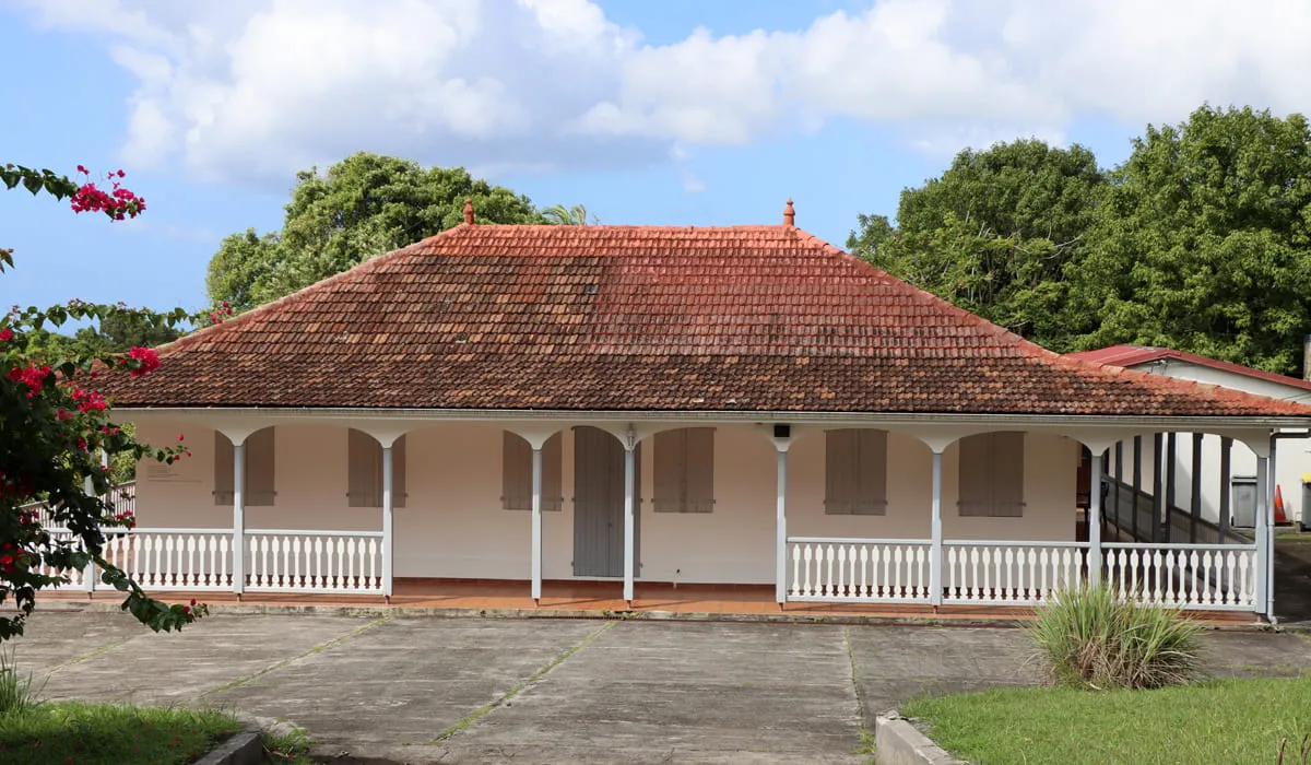
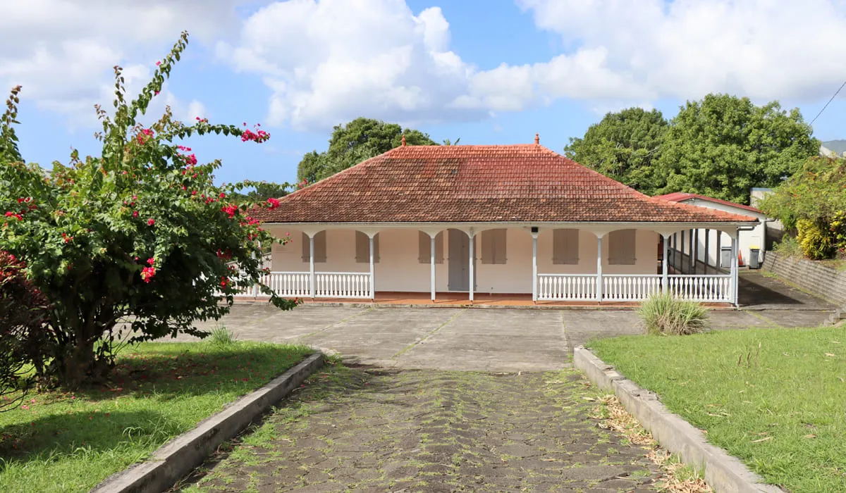
Around the main house, which dates from 1820, stand two additional buildings: the “Senator’s Pavilion,” built as the office of Amédée Knight, senator of Martinique who lived there, and another structure that served as a storage area, water house, and stable. Much farther downhill lies the “rue cases-nègres,” which was the living area for enslaved people and later for agricultural workers.

The first owner of the estate was Chambert Anthoine, known as La Rivière, originally from Agde (Hérault), according to documents from 1671. At that time, the property covered about 150 hectares. In 1680, the estate was home to the master, his wife, their two children, and 80 enslaved Africans. Until 1928, nine different owners succeeded one another, including the Knight family, whose patriarch Amédée Alexis Augustin Knight was a descendant of a Black man born in Martinique. Knight, an engineer trained at the École Centrale de Paris, became senator of Martinique in 1899.

A planter and distiller in Saint-Pierre, he acquired the land in the early 20th century, at a time when the sugar industry was in crisis and plantation bankruptcies were common. Despite this, the estate experienced remarkable prosperity under his management. Its surface area expanded from 136 to 285 hectares, and he established a distillery that produced a high‑quality rum, “H.B.S. rum,” which won a gold medal at the Colonial Exhibition in Paris in 1932.

It was also during this period, between 1900 and 1912, that the estate took the name Beauséjour. When Amédée Knight’s heirs sold the property in 1928 to the “béké” Pierre François Honoré Louis de Lucy de Fossarieu, it had grown by another 50 hectares. Sugarcane cultivation and rum production continued, while cacao declined in favor of secondary crops such as corn, beans, and sweet potato. After the Second World War, banana cultivation took over, and rum production ceased in 1958.

For several years, banana was the estate’s main crop, until sugarcane once again became predominant in more recent times.

The estate was listed in the French Register of Historic Monuments in September 1996. It now produces a high‑quality rum that visitors can taste during the tour.

To reach the estate from Fort‑de‑France, follow the N3 to Ajoupa‑Bouillon, then take the N1 toward Basse‑Pointe, Macouba, and Grand‑Rivière. Before entering the village, turn left.

Saint Louis Cathedral

St. Louis Cathedral is a Roman Catholic cathedral. It is located in the heart of the city of Fort-de-France. On neogothic inspiration, his arrow would measure about 59 meters. Placed under the patronage of the King of France St. Louis, it was the seat of the bishopric of Martinique, erected in 1850 by a bull of Pope Pius IX, and is currently the seat of the Archbishop of Saint Pierre and Fort de-France since 1967. It was designed according to the plans of Pierre-Henri Picq and was inaugurated in 1895.

It was established at the site of the previous cathedral, destroyed by a cyclone in 1891.

Its frame is entirely metal and designed to withstand fire, earthquakes and cyclones. The interior stained glass windows tell the story of the city, or the life of St. Louis and evoke the Roman-Byzantine architecture.

Martinican people are fervent believers in the Catholic religion and the event those masses or weekly Sunday and Saturday nights, the church is always full.

So if you want to get inside, go for a weekday, preferably in the morning. It was recently renovated to restructure its exterior to reflect its origin in 2010.

Photo gallery
Saint Louis Cathedral

Aubéry Castle

The Aubéry Castle, formerly known as Maison Rivail, is a construction dating from the early 20th century. It belonged to Eugène Aubéry (1879–1942). Eugène Aubéry was a white man of modest origins. His marriage to Berthe Hayot, daughter of Gabriel Hayot, a major landowner, propelled him into the highest economic circles.

He first served as administrator of the central factory of Lareinty and later became General Councillor of Lamentin.

Built between 1928 and 1931, the four‑story castle, with its 30 rooms, reflects the status of its wealthy landowner. To enhance the prestige of the building, architects Balesco and Volpi favored a neoclassical style, as evidenced by the porch leading to a double circular staircase, whose mosaic bears the initials of the owner, “AE, year 1930.”

Eugène Aubéry was implicated in the assassination of André Aliker on January 12, 1934, of which he was very likely the instigator. In 1942, upon his death, his wife and eight children left Maison Rivail.

The castle then became the property of the General Council of Martinique. In 1954, it housed the École Normale and later the agricultural school.

Abandoned thereafter, it was sold for a symbolic one franc to the municipality of Ducos in 1987. The building has been protected as a Historic Monument since December 31, 1992.

As its materials deteriorated under the effects of the climate, restoration was necessary to return the edifice to its former glory.

It is located in the Croix-Rivail district, near the old François road (RN6). It is not currently open to visitors due to ongoing works.

Canal des esclaves

The Canal des Esclaves (slaves canal) also called Canal de Beauregard is a place to hike on the heights of Carbet to the Fonds-Mascret neighborhood of Fonds-Saint-Denis. Built in 1760, it owes its name "Canal de Beauregard" to the man who had the idea of ​​conception, Mr. Beauregard then was subsequently appointed Canal des Esclaves to honor the men who carried on their backs stone for its construction.

It was once a vestige of the economic life of the 18th century. Its main purpose was to supplement traditional energy sources used hitherto namely windmills and animals mills. It was also used to carry water from the river Carbet to the Houses of the Caribbean Coast and so irrigate crops. Today is a walk of nearly 7km in a splendid natural setting.

It is a place to hike a 3.5 km length each way. Hiking is possible all year round but just try to avoid doing the wet weather. You can choose to start your hike either Carbet or in Fonds-Saint-Denis.

While safe, this ride is not recommended for those prone to vertigo, as the coping (cemented band) of the channel on which it is circulating in some places wide 30cm only overlooking ravines over 100 meters. The narrow path requires walkers to follow in single file. Throughout the tour, you will be immersed in the natural environment with tropical flora and fauna such as small crabs harmless.

Do not forget to wear sneakers and something to eat if you intend to carry the entire hike. Your camera will allow you to take great photos due to different views offered by this hike as the Pitons of Carbet.

Photo gallery
Parcours du Canal des Esclaves

Espace Camille Darsières

The Camille Darsières Cultural Center is located in the former courthouse, a neoclassical building designed in 1906 by the contractor Gustave de Laguarigue. It stands at the intersection of Perrinon, Schoelcher, and Moreau-de-Jones streets.

Originally, this site was home to the convent of the Daughters of Providence, founded in the 18th century by Father Charles François de Coutances. In 1764, he donated it to the colony on the condition that both religious and secular instruction be provided there, along with classes in dance and etiquette. It later became the courthouse of Martinique.

Following the construction of a new, more modern and functional courthouse, the old building was transformed into a space dedicated to culture. Today, it houses the SERMAC (Municipal Service for Cultural Action of Fort-de-France), while its facilities at the Floral Park of Fort-de-France undergo renovation. The SERMAC plays a key role in the Fort-de-France Cultural Festival.

In the middle of the garden stands a statue of Victor Schoelcher, at the base of which is inscribed: “No French land can ever again bear slaves.” The center is named after Camille Darsières, a former lawyer and deputy of Martinique, who passed away in 2006.

Photo gallery
Espace Camille Darsières